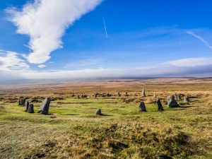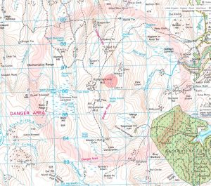

 One of my more crazy ideas. It has long been known that the north east of Dartmoor contains a 'crescent' of 7 stone circles - often referred to as 'The Sacred Crescent' (a term that seems to have first been used in publication by Tim Sandles in 2016 on his Legendary Dartmoor website). Butler (1991, Vol.2, pg.192) states; "Scorhill is one of a group of seven stone circles aligned in a curve around the north-east border of the moor.. ..The intervals between.. ..is a fairly consistent 2 kilometres, suggesting each was constructed as part of a comprehensive design.. ". The relatively recent discovery of a stone circle at Sittaford served to bolster the possibility of a deliberate stone circle arc. Years ago (before the discovery of Sittaford and around the time that Butler published his series of volumes (Dartmoor Atlas of Antiquities) I considered the possibility that if a crescent of stone circles truly exists then it might continue with further, as yet, undiscovered stone circles and perhaps that crescent might just be a part of a whole circle of stone circles? Referring to an Ordnance Survey map the centre of this massive neolithic circle would be located right in the middle of Watern Combe.. a natural amphitheatre that could have contained literally thousands of people in a neolithic ceremony. There doesn't seem to be any regular theme to the placement of the already discovered stone circles - although ridges/cols do seem slightly favoured. The 8 are; White Moor (a ridge), Buttern Hill (a col or saddle), Scorhill (slope on edge of bog), Shovel Down (slope), Fernworthy (spur), Grey Wethers North, Grey Wethers South (both on a col or ridge) and the most recently discovered Sittaford (ridge). They are not on the nearest high point but they can be on ridges, saddles, spurs or slopes. Dartmoor contains other stone circles outside of the crescent - there are at least 15 stone circles within the Dartmoor National Park (and at least two further have been announced 2024). No stone circles have been found within the proposed sun circle. Using all of this information I have plotted a circular path that can be followed, it is approximately 19 km or about 12 miles (not including the walk in and back to your first chosen point or a possible walk to the Watern Combe 'centre'). I am not suggesting that the additional points selected are exactly where other stone circles may await discovery - just that following these 'waypoints' should result in walking through or very close to many such possible locations. I called this project 'The Dartmoor Sun Circle' and completed this walk immediately following the end of first Lockdown (2020 Covid Pandemic). Just visiting each of these possible locations in a long circular walk to take a photographs and sit and wonder was my purpose. (RJN).
Update (7 July 2024): Although I came up with the idea of a Sun Circle independently (decades before Sittaford circle was discovered) and published my ideas here in 2020, I have since been made aware that an archaeologist has also postulated the possibility of a larger circle of stone circles in north east Dartmoor, but has to date not published his theories or evidence (R.Naylor).
Download all Sun Circle Waypoints as a .gpx file for use with a GPS device.
The map below is set to a maximum zoom of 1:50k. To zoom into the map further (1:25k) you need to be a subscriber. You can become a subscriber by visiting this page.
Or login here if you are already a subscriber.


