


 DarteRoutes
Also includes: “DarteThemes”.
These pages and routes are currently being developed. Please don’t use as data and descriptions will not be reliable yet. This page has been made visible so that you can view the progress being made with this amazing new feature!
‘DarteRoutes’ are Dartmoor Routes that assist in visiting Dartefacts and offering ideas for; walks, backpack camping, ‘wild’ swimming, running, long distance multi-day hikes and mountain biking. They usually follow well-known tracks or open moorland that is easy to travel and navigate along. Some Routes are quite Strenuous and all are graded according to the difficulty and challenges encountered.
‘DarteThemes’ gathers Dartefact items that don’t usually belong in a classification together. An example would be ‘The Wisht List’ which collects many Dartefact items that relate to myth, legend and the supernatural on Dartmoor. No route is suggested for DarteThemes, but you could come up with your own to visit these selected items.
ADMIN ACCESS REQUIRED: Route Descriptions
CLICK HERE: For important information to read before attempting any listed route
PRIVATE LAND: Many of the items listed on this website, especially around the edges of the National Park Boundary, are entirely on private land and in that instance access must be sought from the landowner before visiting. Do not assume that a listed item is legally accessible.
ACCESS: The depiction of a public right of way on the map is for leisure purposes and does not necessarily determine a legal right of access. The definitive map and statement hold that information by Parish and are available for viewing, by prior appointment, at the Devon County Council offices.
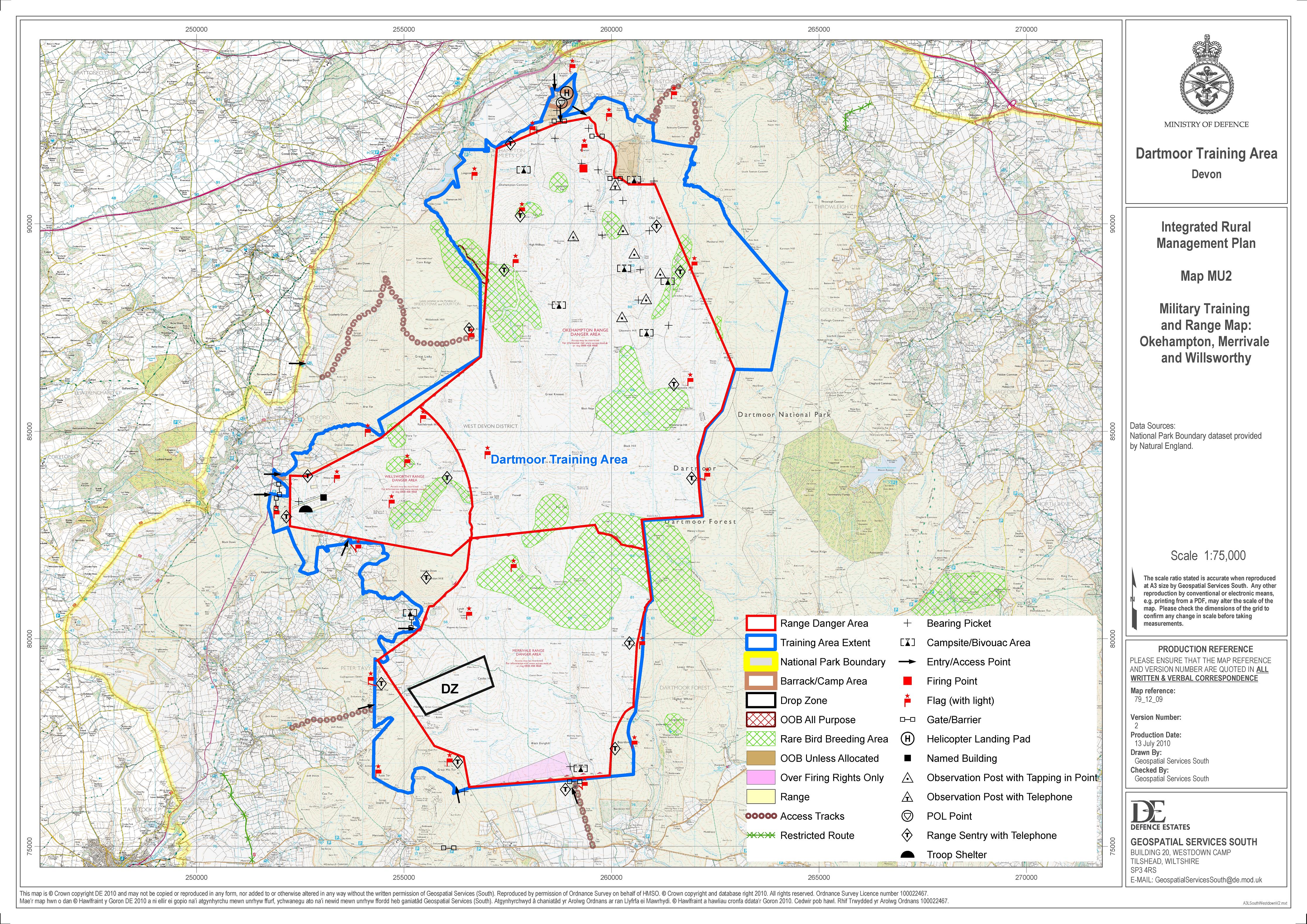
FIRING RANGES: Military Training involving Live Firing takes place on Dartmoor and it is up to the individual to find out if their route enters any of the military firing ranges and whether firing is taking place.
IMPORTANT SAFETY INFORMATION: The red GPX lines that have been provided to indicate the firing range boundaries are not official – so use as a general guide only. The correct source for Dartmoor Firing Range information is here: MOD Firing Range Times & MOD Firing Range Map. The DNPA Visitor Centres also provide daily firing information.
RISK ASSESSMENT: Although these routes attempt to highlight points of potential difficulty via the ‘Challenges’, as with any outdoor activity it is the responsibility of the individual to judge and ascertain the safety and suitability of any route attempted.
SAFETY IN THE OUTDOORS: It is not Dartefacts remit to provide any advice on safety in the outdoors. Dartefacts recommends reading ‘Walking on Dartmoor’, Published by Cicerone, Steve Davison (2023).
LEGAL DISCLAIMER: No responsibility for trespass, injury or damage to property or persons etc. can be attributed to this website and the author of these routes.
DATA: All data and GPX map lines on this website should all be considered approximate and subjective. Some items may no longer exist – but are recorded anyway as it is curious to know that they were once there – and they may yet turn up.
CLICK HERE: For Route Effort Grades and Challenges
DarteRoutes are first ‘automatically’ graded for walking using a time/ effort calculation based on total distance and ascent. A simple ‘traffic light’ colour system (ie. green, orange, red) is used to indicate this grade (easy, moderate, strenuous). Further route information/ data is also available on the DarteRoute pages themselves to allow for a more informed route selection process. A route’s ‘automatic’ ‘effort grade’ can be subjectively overridden by a website Admin and an alternative grade assigned if it contains Challenges significantly different to its initial effort calculation.
Easy (Green): “An hour’s stroll” up to 2 hours walking time
Easy Routes are usually up to an hour long, although a few routes that can take up to 2 hours are included. Easy Routes should follow clear trails or tracks or easy to walk on open moors. Some of these routes are mobility friendly (i.e. suitable for; scooter, pushchair, wheelchair etc.), although the terrain may undulate. These routes attempt to minimise the inclusion of Challenges but where an Easy Route contains a Challenge it should be clearly identified in the Route Summary. The longer an Easy Route is the less Challenges it should contain.
Moderate (Orange): 2-4 hours walking time
Moderate Routes are up to 4 hours long. Every possible Dartmoor terrain can be encountered and so these routes require good navigation skills and confidence moving over difficult ground. Challenges occur but these should not be sustained or overly frequent, especially as the route length increases.
Strenuous (Red): 4+ hrs walking time
Strenuous Routes require 4 hours or more of walking time. Multiple and sustained Challenges can be encountered frequently and so these routes often require excellent navigation skills and a high degree of moorland experience and confidence. Some of these routes are designed as either multi-day wild camping hikes, which will require carrying camping equipment, or as lightweight running/ fast walk routes to be attempted in a single day (possibly with support). Every possible Dartmoor terrain except rock climbing or serious scrambling can be encountered and so these routes necessitate excellent technical navigation, safe movement and confident route finding over difficult terrain.
Challenges:
A ‘Challenge’ is very subjective – what one person finds easy another might find insurmountable.
DarteRoutes considers the following as potential ‘challenges’ that can influence a Route Grade; stiles, difficult terrain (ie. rocky ground/ scree (known as clitter on Dartmoor)/ scrambling (ie. clambering over rocks rather than the ‘technical’ climbers version), mire/ bog crossings, tussucky moorland, river crossings (ie. stepping stones, fords, sheep leaps, narrow or wobbly ‘bridges’), roads (sustained road use with no pavement or busy road crossings), navigation issues (ie. firing ranges, absence of a sustained visible path, featureless ground in deep moorland that requires competent navigation skills in poor weather), sustained steep ascents or descents and, of course, Pixies (well, it is Dartmoor).
Although Routes graded as Easy try to avoid ‘Challenges’ where they exist they are identified in the route summary. Please read the DarteRoute page in full before attempting any listed route.
CLICK HERE: For additional DarteRoutes’ Information
Route Start and Finish and Route Choice
All DarteRoutes start at or near car parks, although you are encouraged to use public transport wherever possible. Some Linear DarteRoutes work very well by parking at the finish and taking a bus to the start point rather than returning back the way you came. Dartefacts only describes where a DarteRoute Starts and Finishes and does not provide further details on getting to the Start or how to manage your travel arrangements. The start and finish point and an entire route itself are only suggestions, many routes have several potential start/ finish points and various route options – please feel free to adapt these routes to suit your own requirements.
SubRoutes (SRs)
DarteRoutes are actually consructed from ‘SubRoutes’ that contain a short route description and walking data (e.g. distance, ascent and descent) and are given a code name such as ‘SR 7′ (i.e. ‘SubRoute Number 7’). SubRoutes give DartRoutes their unique guidebook writing style and provide a very powerful way to generate routes for Dartmoor.
Data Calculations
Distance/ Ascent/ Descent: Each individual SubRoute holds this data and Dartefacts use these to calculate totals for each DarteRoute. Due to ‘rounding off’ it is possible for some circular walks to end up with slightly different ascent/ descent totals.
Time: The length of time a route might take (to walk) is calculated as an hour for every 4 km of distance travelled plus 1 minute for every 10 m of ascent. This total is then used directly to provide the route with an ‘effort grade’; up to 1 hour = Easy, up to 4 hours = Moderate and over 4 hours = Strenuous. ‘Challenges’ can override this initial grade. Route Time does not take into account rest breaks, time spent enjoying views or exploring items.
Steps: The number of steps a route might take is calculated at 2500 Steps per Mile.
Approximate: Route Effort Grades, Route Descriptions and even Route ‘Data’ (Distance, Ascent, Descent, Time, Steps etc.), should all be considered approximate and subjective.
‘Rule of Thumb’: Time and Steps should be used as a guide and self-adjusted as your experience increases. If you find you take a different amount of time to complete these routes then adjust your future route timings accordingly.
Map Information
Route Lines (Magenta): The magenta lines on the maps are called ‘SubRoutes’. SubRoutes are used to create DarteRoutes.
Darteries (Red): The thin red lines on the map are the ‘Darteries’ – the Dartefacts name for the entire network of popular routes used by Dartmoor Explorers. Darteries are steadily being turned into ‘SubRoutes’ so as to be used to create new DarteRoutes.
Approximate: Route GPX Map Lines on open moorland often indicate a general direction, rather than an exact line to follow.
DarteTabs and the Route Filter
DarteTabs: Under the maps are ‘Tabs’ that can be ‘clicked’ for further information. Blue Tabs are for the Car Park Route Starts and the Route Tabs use the Route Grade ‘Traffic Light’ system. Tabs are grouped together by their 10 km Ordnance Survey square. DarteThemes are the grey coloured Tabs.
Route Filter: Below the Map on this page and on the Car Park Start Pages is a Filter Menu that can be used to focus the available DarteTabs Routes suitable for your desired level of activity effort, skills and physical ability. The Filter feature does not affect the visibility of the GPX route lines on the map.
The Power of the SubRoute..
A lot of what follows is ‘under the hood’ of DarteRoutes but I thought it might be of interest for some to know how DarteRoutes are being created and why the Route Descriptions are so detailed and not written a ‘usual’ guidebook way.. the following needs an update..
SubRoutes:
DarteRoutes are actually made up of one or more ‘SubRoutes’ that contain a description and walking data (distance, ascent and descent) and code name (such as ‘SR 7 SE’ which stands for SubRoute 7 South East). The compass direction in the name is a general direction from the start to the end of the SubRoute. Every ‘map line’ has two Subroutes associated with it that travel in the opposite direction.
Nodes and WayPoints:
Where a SubRoute ends and meets another SubRoute a ‘Node’ occurs. SubRoutes can also contain ‘WayPoints’ if they significantly change direction before they meet the end Node.
Subroutes are selected to make new DarteRoutes. The advantage being if a SubRoute is updated then all the DarteRoutes that use it immediately get updated as well, together with each Route’s data (distance, ascent, descent etc.) DarteRoutes are not just another series of “Dartmoor Walks” but truly harnesses the power of computing. This unique approach calls for a rather different method of ‘guidebook route’ writing as the descriptions cannot assume where a person has come from, where they are going or what their goals for that journey are. However, at the end of every Route Description (if necessary) is a ‘Further Options and Alternatives’ section specific to each DarteRoute. I’m not sure but I suspect no one has ever tried to write a ‘walking guidebook’ in this way before! Maybe there’s a reason for that.. It will take some time to amass enough SubRoutes, but at a certain ‘tipping point’ it will be possible to simply “click-click-click” and a new DarteRoute will be generated almost automatically. This will result in a huge collection of Dartmoor ‘walks’ (etc.) across a variety of distances and other variables and they will all be available with a Dartefacts Subscription. between ‘nodes’, a node is usually a key Dartefact item or a route junction. Every SubRoute is provided a description, distance, ascent and descent data. SubRoutes are selected to create a full route. This is very powerful as it means once created they can be used again and again to create many routes and if a SubRoute requires updating then every DarteRoute that uses that SubRoute also gets instantly updated! DarteRoutes are not your normal ‘Guidebook’ ‘walks’ and because of this they may not read in quite the same way as a traditional guidebook. All text is for navigation apart from anything in parentheses (name and notes) which details something (usually a Dartefact) that can be found on or very near to the route.
SubRoutes have been created via a process of human memory, GoogleEarth, Ordnance Survey Mapping, Anquet, BaseCamp, Strava, MemoryMap, Online Sources and a large collection of Walking Guidebooks.
MAP (below): Click a car park icon for a pop-up with car park location name with the number and the difficulty level of routes available there (Green/ Orange/ Red). Click on the Hyperlink to view that Car Park Start Page and its associated routes in detail. The red lines are GPX routes that have so far been added to Routes.
The map below is set to a maximum zoom of 1:50k. To zoom into the map further (1:25k) you need to be a subscriber. You can become a subscriber by visiting this page.
Or login here if you are already a subscriber.
DARTETABS (below): Click a Blue Tab for Car Park Route Starts or click a Route Tab (Green/ Orange/ Red) for detailed Route Information. Tabs are grouped by their 10 km Ordnance Survey square. Use the Filter Menu below to focus your Tab Route search. DarteThemes are the grey coloured Tabs.


